

Md Shahidul Islam
I'm
About
As a Remote Sensing and GIS Specialist, Full Stack Developer, Content Creator, Trainer, Civil Engineer and Researcher, I bring a unique blend of expertise across multiple fields. With proficiency in Python, Django/GeoDjango, Flutter, React, Machine Learning and ioT integration, I am well-versed in developing robust web and mobile applications. I also specialize in Web-GIS, leveraging advanced GIS tools like ArcGIS Pro, QGIS, Leaflet and OpenLayers to create dynamic geospatial solutions.
My experience spans working with prestigious organizations such as UNDP, USAID, and in Government roles, where I have contributed to a range of impactful projects including Urban & Rural Planning, Disaster Management, Climate Change Adaptation, Climate and Weather Data Analysis, Agricultural Value Chains, Training etc. Additionally, I have served as an Assistant Professor at the University of Dhaka, combining my technical knowledge with a passion for academia and research. As a Content Creator, I regularly share insights and tutorials on emerging technologies, and as a Researcher, I am dedicated to exploring innovative solutions in the fields of engineering, GIS, and software development, big data analysis.
My diverse skills set enables me to leverage cutting-edge technologies to deliver innovative solutions across engineering, geospatial analysis, software development, and educational content creation.
RS & GIS Solutions Provider, Web Developer & Data Analyst.
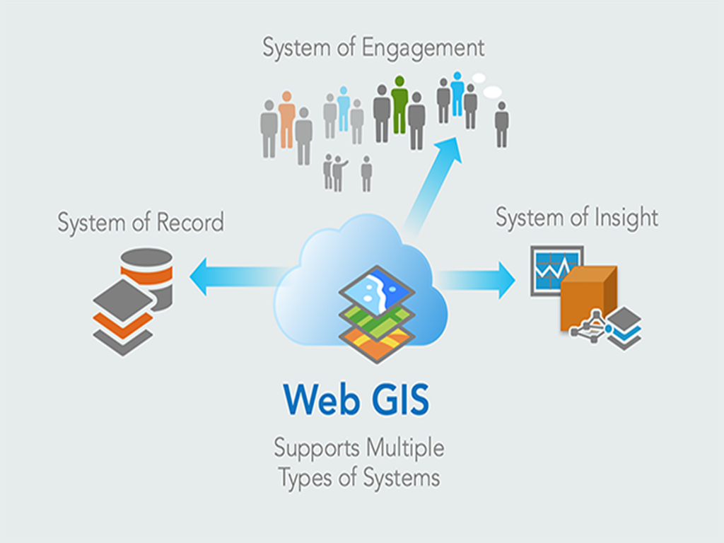
With my expertise in Web-GIS, I specialize in developing vehicle tracking and navigation systems by integrating real-time geospatial data and IoT devices to provide efficient location tracking and fleet management solutions. Additionally, I leverage GIS tools to analyze and visualize weather data, enabling informed decision-making for climate monitoring and forecasting.
- Work Time: 12/7
- Website: www.shahidul.tech
- WhatsApp: +880-1715-534694
- City: Dhaka, Bangladesh
- Education in: Bangladesh, India, Thaland
- Degree: Master
- Email: ms_islam@yahoo.com
- Freelance: Available
A passionate and versatile professional, I am driven by a commitment to continuous learning and innovation in the fields of engineering, GIS, and technology. I thrive in dynamic environments, blending my technical expertise with creative problem-solving to make a positive impact.
Happy Clients: Fiverr & Others
Projects: GIS & Content Creation
Hours Of Support: Delivery on time
Testimonials: Fiverr & Others
Skills
I possess a diverse skill set in RS & GIS, Web Development, Machine Learning, Civil Engineering and IoT, with expertise in technologies like Python, React, Django, Flutter, Leaflet etc..
Resume
With over 35 years of work experience in both academic and practical roles, my deep technical knowledge combined with a broad range of international exposure makes me a well-rounded asset in GIS-based project management and infrastructure development.
Summary
I am highly experienced professional with over 35 years of expertise in Remote Sensing (RS), Geographic Information Systems (GIS), disaster management, and infrastructure planning. I hold a Master of Engineering in RS and GIS from the Asian Institute of Technology (AIT), Thailand, and has worked with organizations like USAID, UNDP, and LGED. My work includes GIS-based disaster risk reduction, urban planning, and the development of geospatial databases and web-GIS applications. I have also contributed to research, training, and policy development in disaster management, urban/rural planning and agricultural value chains.
Education
Master of Engineering in Remote Sensing and GIS
2003 - 2005
Asian Institute of Technology (AIT), Thailand
I have pursued Master of Engineering in Remote Sensing and GIS from the Asian Institute of Technology (AIT), Thailand, specializing in advanced geospatial technologies for environmental monitoring, resource management, and data analysis.
Post Graduate Diploma in Remote Sensing and GIS
1999 - 2000
Center for Space Science and Technology Education in Asia and the Pacific (CSSTE-AP), IIRS, Dehradun, India
I have completed PGD in Remote Sensing and GIS from Center for Space Science and Technology Education in Asia and the Pacific (CSSTE-AP), Indian Institute of Remote Sensing, Dehradu, India, concentrating in advanced geospatial technologies for urban/rural planning, environmental monitoring, resource management, and data analysis.
Bachelor of Science in Civil Engineering
1983 - 1988
Bangladesh University of Engineering and Technology (BUET), BangladeshI have done Bachelor of Science in Civile Engineering from Bangladesh University of Engineering and Technology (BUET), Dhaka, Bangladesh, focusing in urban/rural infrastructures planning, design, supervision and implementation.
Journal Papers
- Identification of Inaccessible Roads and Vulnerable Settlements in Dhaka City Using ArcGIS Tools, International Journal of Disaster Response and Emergency Management, Volume 3, Issue 1, January-June 2020.
- Resilience to flash floods in wetland communities of northeastern Bangladesh, ELSIVIER International Journal of Disaster Risk Reduction 31 (2018), 478-488.
- Storm Surge Modelling based on Analysis of Historical Cyclones for Patuakhali District of Bangladesh, IOSR Journal of Environmental Science, Toxicology and Food Technology, Volume 12, Issue 4 Ver. II (2018)
- A Study on Disaster Management Practices for Vulnerable Rural Communities in Bangladesh, the Bangladesh Journal of Scientific Research, Vol 30, No 1-2 (Mar. 2018)
- Empowering the Vulnerable Women in Disaster Prone Areas: A Case Study of Southern and Northern Region of Bangladesh, IOSR Journal of Humanities and Social Science, Volume 22, Issue 9, Ver. 15(Sep. 2017)
- Rapid Response Mapping using MODIS Image, Dhaka University Journal of Earth and Environmental Sciences, Vol 3, N0. 1, June 2014.
Conference Proceedings
- Information Infrastructure for Disaster Management - International Symposium on Benefiting from Earth Observation, 4-6 October 2010, Kathmandu, Nepal
- Disaster Management using Space Technology in Bangladesh, "Risk Assessment in the Context of Global Climate Change" - United Nations International Conference on Space-based Technologies for Disaster Management held in Beijing, China during November 07-09, 2012, organized by UN-SPIDER Beijing Office.
- Disaster Database in Bangladesh - Expert Group Meeting on Improving Disaster Data to Build Resilience held in Sendai, Japan (Sep 30-Oct 01, 2013), organized by UNESCAP, and Tohoku University, Sendai, Japan.
- On the Spot Identification of Flood Inundation Depth from Gridded Data using GPS enabled Smartphone Application - United Nations/Nepal Workshop on the Applications of GNSS, Nepal, 12-16 December, 2016.
- Status of Using of Space based and In-situ Information in DRR in Bangladesh - United Nations International Conference on Space-based Technologies for Disaster Risk Reduction - "Building Resilience through Integrated Applications", Beijing, China, 23 to 25 October 2017.
- Status of Space Education and its Applications in Bangladesh and Possibility of International Support to Enhance the Present Situation - UN/Russian Federation Workshop on Human Capacity-Building in S pace Science and Technology for Sustainable Social and Economic Development, Samara, Russia, 30 Oct-02Nov, 2017
- Rainwater Induced urban waterlogging at Dhanmondi of Dhaka city: Causes, extent and solution - United Nations International Conference on Space-based Technologies for Disaster Risk Reduction - "Enhancing Disaster Preparedness for Effective Emergency Response", Beijing, China, 24 to 26 October 2018.
Consultancy
- Land use classification of IRAQ War Damaged Database from Quick Bird RS Datasets using ENVI / ArcGIS.
- Development of Web-GIS based Provincial Road Safety Database Management System for TARC, AIT, Thailand using Open Source GIS (PostgreSQL/PostGIS).
- Development of Vehicle Tracking System using Open Source GIS Tools (GeoDjango, PostgreSQL/PostGIS).
- Development of Online Field Data Collection System for ACFI/VOCA, Mozambique, Africa
Software Skills
- GIS - ArcGIS / ArcGIS Pro, ArcView, ArcInfo, Quantum GIS (QGIS), Network/Spatial/3D Analyst, ILWIS.
- Digital Image Processing (RS data) - Erdas Imagine, ENVI, SNAP.
- Database - MS Access, MS SQL Server, MySQL, Oracle, PostrgreSQL/PostGIS, OpenStreetMap.
- OS / Server - Windows, ArcGIS Server, Linux, IIS, Apache, MapServer, GeoServer, LAMP.
- Application Software - AutoCAD, MS Office Suite, SPSS, STATA, CSPro, Adobe PhotoShop, Adobe Illustrator, ArcGIS Field Maps, ArcGIS Survey123, Atlist, Google My maps.
- Programming Language - OpenLayers, Leaflet, ka-map, Geonode, VB, PHP, Laravel, Python, Django, GeoDjango, DRF, Machine Learning, JavaScript, React JS, ASP.Net, CSS, XML, HTML5, AJAX, C, Google Map API, Flutter, R, Shiny, ODK based KoboToolbox, QField, Open-Meteo's API to access and integrate real-time and forecasted weather information into GIS
Training Conducted/Taught
- Imparted One Week Training on ArcGIS Desktop for Ahsanullah University of Science and Technology (AUST), Bangladesh for the Faculty of Department pf Civil Engineering.
- Training on Open Street Mapping (OSM) for Resilience for the Students of Khulna University, Bangladesh.
- GPS field Survey Training for Government and Project Officials.
- Basic and Advanced GIS and Remote Sensing Training for stakeholders in Disaster Management.
- Quantum GIS (QGIS) Training to USAID Agricultural Value Chains (AVC) Project Officials.
- Training on Rapid Response Mapping for Govt. Officials.
Professional Experience
Senior GIS Specialist
Feb/2024 - Present
Local government Engineering Department (LGED), Dhaka, Bangladesh
- Urban Planning using RS and GIS.
- GPS-enabled Smartphone/Tablet-based Infrastructure Surveys using QField/KoboToolbox.
- Geospatial Database Development and Analysis.
- Web-GIS based Project Management System Development
Research and Development Specialist
Jun/2022 - Jan/2024
Monico Technologies Limited, Dhaka, Bangladesh
- Development of GPS-based Vehicle Tracking Systems (Web-GIS) using ArcGIS, QGIS, Python, Django/GeoDjango, PostgreSQL/PostGIS, JavaScript, HTML, and CSS.
- Development of Web-based Community Mapping Tools for Routing and Location Search.
Senior Mission GIS Specialist
May/2019 - May/2022
USAID, Dhaka, Bangladesh
- GIS Database Management using ArcGIS/ArcGIS Pro.
- GIS integration in Monitoring, Evaluation, and Learning (MEL).
- Research on Remote Sensing-based Environmental Degradation Analysis using Google Earth Engine and R.
- Development of Multi-Hazard Maps and Disaster Vulnerability Maps.
- GIS-based Gap Analysis for Disaster Risk Reduction, Agriculture, Health, Education, and Governance.
Assistant Professor (Chairman)
Aug/2016 - Apr/2019
University of Dhaka, Dhaka, Bangladesh
- Teaching, Training, and Research in Disaster Science and Climate Resilience.
- Application of RS and GIS in Humanitarian Emergency & Crisis Management, Disaster Impact Assessment, Prediction and Early Warning, Emergency Planning, Response & Recovery, Damage and Loss Assessment, Mitigation, Prevention, and Preparedness.
GIS Specialist
May/2014 - July/2016
Development Alternatives Inc.(DAI) - USA based INGO, Dhaka, Bangladesh
- GIS Strategic Plan Development for Agricultural Value Chains.
- Manual Development and imparting Training on Quantum GIS (QGIS), GPS, and Smartphone Apps.
- Development of Web-GIS based MIS and Market Actor's Tracker.
- Smartphone-based Data Collection Apps Development.
GIS Mapping Analyst
Sep/2010 - Apr/2014
United Nations Development Programme (UNDP), Dhaka, Bangladesh
- Development of Disaster Management Tools using RS and using GIS (Risk Analysis, Risk Reduction, Early Warning).
- Development of Multi-Hazard Maps, Flood and Cyclone Risk Maps.
- Web-GIS Development for Disaster Incidence and Damage Database.
- Damage and Need Assessment (DNA) using RS and GIS (ArcGIS) for recovery and rehabilitation.
- Development of Open Source Web-GIS based 4W Database to coordinate DRR/CCA Projects.
- Development of Rapid Response Mapping from Satellite Image using Erdas Imagine, ENVI and ArcGIS.
GIS Database Specialist
Jun/2007 - Dec/2009
United Nations Development Programme (UNDP), Dhaka, Bangladesh
- GIS Database Development for Disaster Management (Risk Analysis, Early Warning).
- Development of Cyclone Shelter Database.
- Collection of spatial and non-spatial database down to Sub-Districts level from different primary and secondary sources including Satellite Image, Google Earth, GPS Survey, Data Editing, Storing and Analysis.
Mar/20o6 - Feb/2007
Asian Institute of Technology (AIT), Thailand
- Development of Web-GIS-based Tsunami Tracking and Alerting System
Executive Enginner (MIS/GIS Manager)
Feb/1989 - Aug/2010
Local Government Engineering Department (LGED), Dhaka, Bangladesh
- GIS in Infrastructure Development and Maintenance.
- Geodatabase Development for Small-Scale Water Resources Projects.
- Conversion of File-based GIS Database to Centralized Geodatabase.
- MIS and GIS in Infrastructure Development and Maintenance.
- Creation and Updating of Spatial and Non-Spatial Databases.
- Rural/Urban Infrastructure Development and Maintenance.
- Project Management in Urban and Rural Areas.
Training Received
- The Location Advantage online Course conducted by ESRI, Udemy. [Apr, 2016]
- Two days Training on Mapping for Resilience by GeoCenter, USAID and Khulna University. [Jun, 2015]
- One week Training on Technical Assistance on Implementation of Geo-referenced Information Systems for Disaster Risk Management (Geo-DRM) based on Geonode, conducted by UNESCAP and AIT, Thailand. [Mar, 2014]
- One week long Training on Geospatial Information Technology for DRR: From Risk Assessment to Emergency Response conducted by United Nations Institute for Training and Research (unitar). [Dec, 2013]
- One week training on Space Technology for Flood Hazard Mapping, Flood Forecast, and Rapid Mapping in Bangladesh organized by Department of Disaster Management, UN-SPIDER Beijing Office. [May, 2013]
- One week training on Space-based Information for Disaster Preparedness and Risk Assessment conducted by CDMP and ICIMOD, Nepal. [Apr, 2011]
- One week training at BUET on Flood Hazard Mapping and Socioeconomic Vulnerability Analysis conducted by ICIMOD, Nepal, GeoData Institute, University of Southampton, UK. [May, 2010]
- o One week training on Earthquake Risk Assessment and Planning using GIS based HAZUS tool conducted by ADPC, Thailand and NSET, Nepal. [Aug, 2009]
- One-week BIMSTEC training workshop on Geoinformatics Application in Disaster Management for BIMSTEC Countries Participants at IIRS, Dehradun, India. [Nov, 2007]
- One-week training program on The Potential and Use of Low Moderate Resolution Remote Sensing organized by GIS Application Center (GAC), Asian Institute of Technology (AIT), Thailand. [Oct, 2002]
- One-week training workshop on Sharing Geographic Information on using Internet Mapping Technology organized by International Center for Integrated Mountain Development, Nepal. [Aug, 2002]
- One Month Course on Introduction to Desktop GIS ArcView organized by EGIS, ESRI. [Mar, 2001]
- Three-day Training on Application of GIS to Land use Planning conducted by LGED. [Apr, 1998]
- Four-week certificate course on GIS conducted by Jahangirnagar University, Dhaka, Bangladesh. [Jul, 1997]
Portfolio
I am a skilled professional with a Master of Engineering in Remote Sensing (RS) and Geographical Information Systems (GIS), alongside a Bachelor's degree in Civil Engineering. I have extensive experience in web-GIS-based infrastructure management systems, vehicle tracking, and road safety management, along with expertise in geospatial analysis, mapping, and software/mobile app development. My multidisciplinary background enables me to deliver innovative solutions in both engineering and technology.
Services
I offer professional services in Web-GIS Application Development, GIS Database Management, Satellite Image Analysis, Data Analysis using Machine Learning, Full Stack Web Development, and Mobile App Development, providing tailored solutions to meet client needs and improve decision-making processes
Web-GIS Application Development
I design and develop interactive Web-GIS applications to visualize and analyze geographic data effectively, helping businesses make data-driven decisions.
GIS Database and Analysis
I provide robust GIS database solutions for storing, managing, and analyzing spatial data, ensuring seamless integration and optimal performance.
Satellite Image Analysis
I leverage satellite imagery to extract meaningful insights, including land use/land cover mapping, vegetation analysis, and environmental monitoring.
Data Engineering / Analysis with Macine Learning
I use advanced machine learning techniques to analyze complex datasets, uncover patterns, and provide actionable insights for better business strategies.
Full Stack Web Development
I offer end-to-end web development services, building dynamic, responsive websites and applications from the ground up using modern technologies.
Mobile Apps Development
I create intuitive, cross-platform mobile apps tailored to user needs, helping clients enhance customer engagement and expand their reach on mobile devices.
Testimonials
See what my clients have to say about the quality and impact of my Web-GIS solutions and other development services.
The Web-GIS based vehicle tracking system developed by Mr. Shahidul has greatly enhanced fleet management in Bangladesh, providing real-time tracking and detailed analytics with ease and precision.

Shakhawat Sobhan Gorky
COO & Founder, Finder-LBS, Bangladesh
The work is good. He knows his job.

Idrissabangura
Fiverr Buyer, Sierra Leone
Thank you Shahidul for the exceptional attention to detail and timeliness in your delivery.

Srivaishnavi
Fiverr Buyer, USA
The Web-GIS based Tsunami Tracking and Alerting System developed by Mr. Islam for Thailand has significantly improved our ability to monitor and respond to tsunami threats, ensuring timely alerts and enhanced safety for communities.

Prof. Kiyoshi Honda
Faculty, Chubu University, Japan
Contact
Feel free to get in touch for professional solutions and collaboration opportunities—I'm here to help bring your ideas to life!
Address
House 185, Road 12/A, West Dhanmondi, Dhaka - 1209. Bangladesh
Call Me (WhatsApp)
+880 1715 534694
Email Me
ms_islam@yahoo.com